Alnāvar night lights from space
Night Light of Alnāvar (Karnataka) from space (India) Src. Average luminocity for 10x10km area is 6.5606% and for 50x50km: 4.758%.
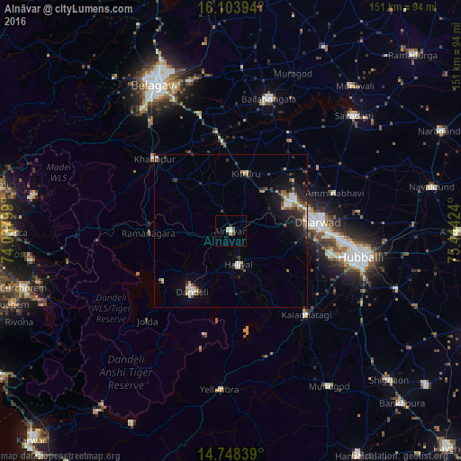
Analysis of Alnāvar night lights 2016
Square area 10x10 km:
 1.3%
1.3%90-99
1.95%80-89
0.22%70-79
0%60-69
1.08%50-59
0.65%40-49
1.52%30-39
0.22%20-29
0.87%10-19
0%0-9
92.21%Square area 50x50 km:
0.46%90-99
1%80-89
0.34%70-79
0.42%60-69
0.54%50-59
0.53%40-49
0.79%30-39
0.73%20-29
1.59%10-19
2.99%0-9
90.6%Clear (daylight) street map image can be seen on geolist.org.
Map coordinates:
16° 6' 14.2" North, 74° 2' 16.8" East
15° 25' 38.2" North, 74° 44' 28" East
14° 44' 54.2" North, 75° 26' 39.3" East
Some cities around Alnāvar sort by population:
• Hubli
43 km =26.7 mi,  101°
101°
• Dandeli
22.3 km =13.9 mi,  216°
216°
• Bail-Hongal
44.8 km =27.8 mi,  16°
16°
• Haliyal
11.1 km =6.9 mi,  171°
171°
• Yellāpur
51.7 km =32.1 mi,  183°
183°
• Khānāpur
34.3 km =21.3 mi,  313°
313°
• Kalghatgi
36.7 km =22.8 mi,  137°
137°
• Londa
24.2 km =15 mi,  281°
281°
1278973 (p: 16,926)
Sources (retrieved 2019-11-25):
» Earth at Night: Flat Maps 2012, 2016