Ankola night lights from space
Night Light of Ankola (Karnataka) from space (India) Src. Average luminocity for 10x10km area is 12.9286% and for 50x50km: 3.653%.
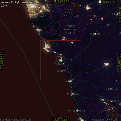
Analysis of Ankola night lights 2016
Square area 10x10 km:
 0%
0%90-99
1.73%80-89
1.52%70-79
1.95%60-69
1.52%50-59
3.68%40-49
1.73%30-39
2.81%20-29
3.25%10-19
1.3%0-9
80.52%Square area 50x50 km:
0.39%90-99
0.69%80-89
0.36%70-79
0.25%60-69
0.38%50-59
0.54%40-49
0.41%30-39
0.73%20-29
0.93%10-19
2.71%0-9
92.6%Clear (daylight) street map image can be seen on geolist.org.
Map coordinates:
15° 20' 22.7" North, 73° 36' 5.7" East
14° 39' 37.8" North, 74° 18' 16.9" East
13° 58' 45.2" North, 75° 0' 28.2" East
Some cities around Ankola sort by population:
• Karwar
25.4 km =15.8 mi,  312°
312°
• Sirsi
57.3 km =35.6 mi,  94°
94°
• Kumta
28.6 km =17.8 mi,  154°
154°
• Gokarna
12.4 km =7.7 mi,  174°
174°
• Yellāpur
55 km =34.2 mi,  52°
52°
• Honāvar
44.8 km =27.8 mi,  160°
160°
• Kānkon
49.3 km =30.6 mi,  325°
325°
• Canacona
46.2 km =28.7 mi,  323°
323°
1278551 (p: 14,540)
Sources (retrieved 2019-11-25):
» Earth at Night: Flat Maps 2012, 2016