Yelbarga night lights from space
Night Light of Yelbarga (Karnataka) from space (India) Src. Average luminocity for 10x10km area is 8.6732% and for 50x50km: 4.2528%.
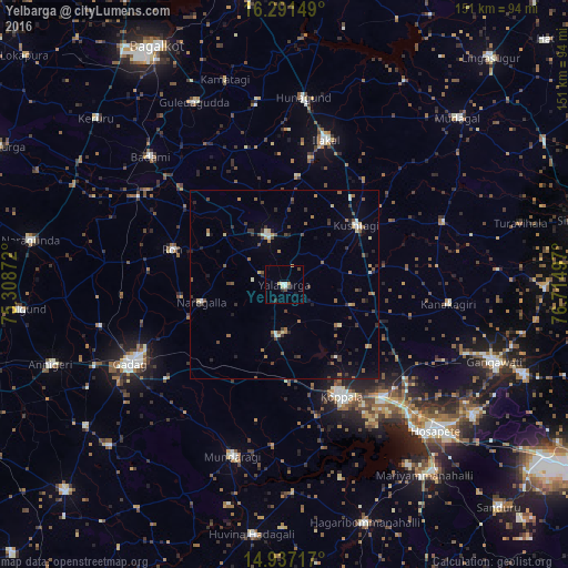
Analysis of Yelbarga night lights 2016
Square area 10x10 km:
 1.08%
1.08%90-99
2.38%80-89
0.87%70-79
0.65%60-69
0.65%50-59
0%40-49
2.16%30-39
0.87%20-29
1.3%10-19
1.73%0-9
88.31%Square area 50x50 km:
0.21%90-99
0.51%80-89
0.46%70-79
0.3%60-69
0.69%50-59
0.69%40-49
0.78%30-39
1.02%20-29
0.94%10-19
1.14%0-9
93.26%Clear (daylight) street map image can be seen on geolist.org.
Map coordinates:
16° 17' 29.4" North, 75° 18' 31.4" East
15° 36' 55.6" North, 76° 0' 42.6" East
14° 56' 13.8" North, 76° 42' 53.9" East
Some cities around Yelbarga sort by population:
• Gadag
45.9 km =28.5 mi,  243°
243°
• Koppal
33.7 km =20.9 mi,  152°
152°
• Ilkal
39.7 km =24.7 mi,  15°
15°
• Gajendragarh
14.2 km =8.8 mi,  341°
341°
• Kushtagi
24.8 km =15.4 mi,  50°
50°
• Ron
31.2 km =19.4 mi,  287°
287°
• Mundargi
47.5 km =29.5 mi,  196°
196°
• Naregal
22.3 km =13.9 mi,  257°
257°
1252753 (p: 12,023)
Sources (retrieved 2019-11-25):
» Earth at Night: Flat Maps 2012, 2016