Wallajahbad night lights from space
Night Light of Wallajahbad (Tamil Nadu) from space (India) Src. Average luminocity for 10x10km area is 21.5909% and for 50x50km: 32.4677%.
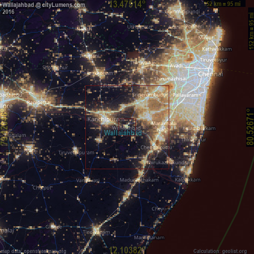
Analysis of Wallajahbad night lights 2016
Square area 10x10 km:
 0%
0%90-99
0%80-89
4.98%70-79
1.08%60-69
1.3%50-59
3.46%40-49
4.33%30-39
7.58%20-29
10.39%10-19
32.68%0-9
34.2%Square area 50x50 km:
1.27%90-99
4.51%80-89
7.84%70-79
4.23%60-69
7.16%50-59
6%40-49
5.31%30-39
5.31%20-29
8.2%10-19
14.69%0-9
35.48%Clear (daylight) street map image can be seen on geolist.org.
Map coordinates:
13° 28' 30.5" North, 79° 7' 13.7" East
12° 47' 25.5" North, 79° 49' 24.9" East
12° 6' 13.8" North, 80° 31' 36.2" East
Some cities around Wallajahbad sort by population:
• Kanchipuram
14.3 km =8.9 mi,  290°
290°
• Chingleput
19.9 km =12.4 mi,  123°
123°
• Gūduvāncheri
26.4 km =16.4 mi,  76°
76°
• Uttiramerūr
20.8 km =12.9 mi,  200°
200°
• Srīperumbūdūr
23.5 km =14.6 mi,  33°
33°
• Madambakkam
25.2 km =15.7 mi,  74°
74°
• Singapperumālkovil
20.2 km =12.6 mi,  99°
99°
• Dūsi
15.8 km =9.8 mi,  264°
264°
1252998 (p: 10,543)
Sources (retrieved 2019-11-25):
» Earth at Night: Flat Maps 2012, 2016