Dūsi night lights from space
Night Light of Dūsi (Tamil Nadu) from space (India) Src. Average luminocity for 10x10km area is 28.9437% and for 50x50km: 16.6212%.
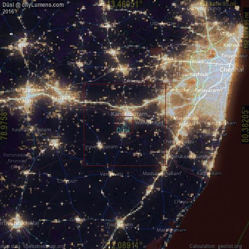
Analysis of Dūsi night lights 2016
Square area 10x10 km:
 0%
0%90-99
6.71%80-89
1.95%70-79
2.6%60-69
1.52%50-59
3.68%40-49
10.82%30-39
5.41%20-29
13.85%10-19
37.45%0-9
16.02%Square area 50x50 km:
0.25%90-99
1.63%80-89
2.89%70-79
1.88%60-69
1.71%50-59
3.02%40-49
3.96%30-39
4.36%20-29
6.89%10-19
13.04%0-9
60.37%Clear (daylight) street map image can be seen on geolist.org.
Map coordinates:
13° 27' 37.8" North, 78° 58' 32.9" East
12° 46' 32.7" North, 79° 40' 44.1" East
12° 5' 20.8" North, 80° 22' 55.4" East
Some cities around Dūsi sort by population:
• Kanchipuram
7 km =4.3 mi,  19°
19°
• Arakkonam
34.3 km =21.3 mi,  358°
358°
• Chingleput
33.6 km =20.9 mi,  106°
106°
• Cheyyar
19.5 km =12.1 mi,  228°
228°
• Vandavāsi
31.2 km =19.4 mi,  194°
194°
• Uttiramerūr
19.9 km =12.4 mi,  154°
154°
• Wallajahbad
15.8 km =9.8 mi,  84°
84°
• Kalavai
28.1 km =17.5 mi,  268°
268°
1272156 (p: 5,257)
Sources (retrieved 2019-11-25):
» Earth at Night: Flat Maps 2012, 2016