Srīperumbūdūr night lights from space
Night Light of Srīperumbūdūr (Tamil Nadu) from space (India) Src. Average luminocity for 10x10km area is 72.7706% and for 50x50km: 54.8948%.
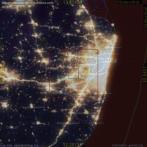
Analysis of Srīperumbūdūr night lights 2016
Square area 10x10 km:
 3.25%
3.25%90-99
14.5%80-89
23.81%70-79
13.2%60-69
22.08%50-59
15.58%40-49
6.06%30-39
1.52%20-29
0%10-19
0%0-9
0%Square area 50x50 km:
5.41%90-99
11.85%80-89
16.31%70-79
6.75%60-69
9.25%50-59
8.55%40-49
6.12%30-39
6.69%20-29
7.67%10-19
10.55%0-9
10.83%Clear (daylight) street map image can be seen on geolist.org.
Map coordinates:
13° 39' 6.7" North, 79° 14' 19.9" East
12° 58' 3.5" North, 79° 56' 31.1" East
12° 16' 53.4" North, 80° 38' 42.4" East
Some cities around Srīperumbūdūr sort by population:
• Tambaram
20.6 km =12.8 mi,  103°
103°
• Poonamalle
20.8 km =12.9 mi,  64°
64°
• Tiruvallur
19.9 km =12.4 mi,  349°
349°
• Gūduvāncheri
18.7 km =11.6 mi,  136°
136°
• Tinnanūr
18.8 km =11.7 mi,  29°
29°
• Madambakkam
17.1 km =10.6 mi, 138°
• Vandalūr
17.2 km =10.7 mi,  119°
119°
• Nandambakkam
13.7 km =8.5 mi,  85°
85°
1255630 (p: 17,253)
Sources (retrieved 2019-11-25):
» Earth at Night: Flat Maps 2012, 2016