Uttiramerūr night lights from space
Night Light of Uttiramerūr (Tamil Nadu) from space (India) Src. Average luminocity for 10x10km area is 7.4091% and for 50x50km: 14.3983%.

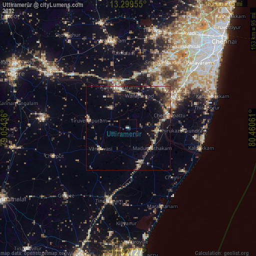
Analysis of Uttiramerūr night lights 2016
Square area 10x10 km:
 0%
0%90-99
0%80-89
0.87%70-79
0%60-69
0.87%50-59
4.11%40-49
1.08%30-39
1.73%20-29
6.06%10-19
1.73%0-9
83.55%Square area 50x50 km:
0.23%90-99
1.42%80-89
2.51%70-79
1.34%60-69
1.84%50-59
2.95%40-49
3.67%30-39
3.52%20-29
4.87%10-19
11.64%0-9
66.01%Clear (daylight) street map image can be seen on geolist.org.
Map coordinates:
13° 17' 58.4" North, 79° 3' 15.7" East
12° 36' 51.6" North, 79° 45' 26.9" East
11° 55' 38.2" North, 80° 27' 38.2" East
Some cities around Uttiramerūr sort by population:
• Kanchipuram
25.3 km =15.7 mi,  345°
345°
• Chingleput
25.3 km =15.7 mi,  70°
70°
• Cheyyar
23.8 km =14.8 mi,  282°
282°
• Vandavāsi
20.5 km =12.7 mi,  233°
233°
• Madurāntakam
17.9 km =11.1 mi,  129°
129°
• Wallajahbad
20.8 km =12.9 mi,  20°
20°
• Singapperumālkovil
31.6 km =19.6 mi,  59°
59°
• Dūsi
19.9 km =12.4 mi,  334°
334°
1253623 (p: 24,315)
Sources (retrieved 2019-11-25):
» Earth at Night: Flat Maps 2012, 2016