Vāghodia night lights from space
Night Light of Vāghodia (Gujarat) from space (India) Src. Average luminocity for 10x10km area is 28.8996% and for 50x50km: 22.7842%.
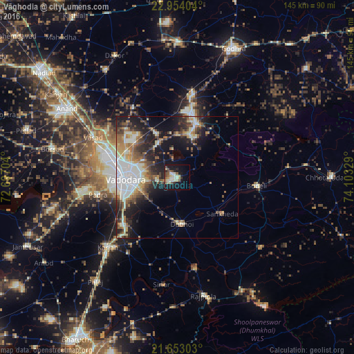
Analysis of Vāghodia night lights 2016
Square area 10x10 km:
 3.03%
3.03%90-99
6.63%80-89
5.49%70-79
0.76%60-69
4.92%50-59
2.27%40-49
5.3%30-39
1.89%20-29
4.36%10-19
31.25%0-9
34.09%Square area 50x50 km:
3.68%90-99
5.2%80-89
2.51%70-79
2.3%60-69
3.02%50-59
3.14%40-49
3.39%30-39
3.56%20-29
6.08%10-19
12.14%0-9
54.97%Clear (daylight) street map image can be seen on geolist.org.
Map coordinates:
22° 57' 14.5" North, 72° 41' 49.3" East
22° 18' 18.2" North, 73° 24' 0.6" East
21° 39' 10.9" North, 74° 6' 11.8" East
Some cities around Vāghodia sort by population:
• Vadodara
19.8 km =12.3 mi,  268°
268°
• Dabhoi
14 km =8.7 mi,  165°
165°
• Hālol
23.3 km =14.5 mi,  18°
18°
• Padra
33.3 km =20.7 mi,  257°
257°
• Kālol
34.3 km =21.3 mi,  10°
10°
• Sankheda
23.7 km =14.7 mi,  129°
129°
• Sinor
44.2 km =27.5 mi,  188°
188°
• Shivrājpur
25.1 km =15.6 mi,  58°
58°
1253559 (p: 14,606)
Sources (retrieved 2019-11-25):
» Earth at Night: Flat Maps 2012, 2016