Utrān night lights from space
Night Light of Utrān (Gujarat) from space (India) Src. Average luminocity for 10x10km area is 92.1905% and for 50x50km: 45.4926%.
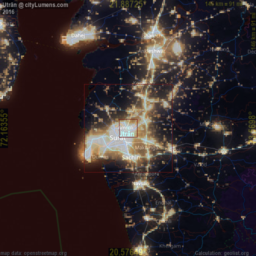
Analysis of Utrān night lights 2016
Square area 10x10 km:
100  39.09%
90-99 34.72%
80-89 11.71%
70-79 7.94%
60-69 4.17%
50-59 1.39%
40-49 0.99%
30-39 0%
20-29 0%
10-19 0%
0-9 0%
39.09%90-99
34.72%80-89
11.71%70-79
7.94%60-69
4.17%50-59
1.39%40-49
0.99%30-39
0%20-29
0%10-19
0%0-9
0%Square area 50x50 km:
100 6.94%
90-99 11.29%
80-89 7.16%
70-79 5.09%
60-69 6.5%
50-59 6.62%
40-49 6.56%
30-39 7.35%
20-29 9.4%
10-19 12.77%
0-9 20.32%
6.94%90-99
11.29%80-89
7.16%70-79
5.09%60-69
6.5%50-59
6.62%40-49
6.56%30-39
7.35%20-29
9.4%10-19
12.77%0-9
20.32%Clear (daylight) street map image can be seen on geolist.org.
Map coordinates:
21° 53' 14.1" North, 72° 9' 48.8" East
21° 13' 60" North, 72° 52' 0" East
20° 34' 35.4" North, 73° 34' 11.3" East
Some cities around Utrān sort by population:
• Sūrat
5.6 km =3.5 mi,  222°
222°
• Bārdoli
28.2 km =17.5 mi,  115°
115°
• Kosamba
27.1 km =16.8 mi,  20°
20°
• Jalālpur
31.8 km =19.8 mi,  174°
174°
• Amroli
3.5 km =2.2 mi,  303°
303°
• Kāthor
9.8 km =6.1 mi,  51°
51°
• Olpād
16.5 km =10.3 mi,  313°
313°
• Sachīn
16.3 km =10.1 mi, 174°
1253640 (p: 14,855)
Sources (retrieved 2019-11-25):
» Earth at Night: Flat Maps 2012, 2016