Kāthor night lights from space
Night Light of Kāthor (Gujarat) from space (India) Src. Average luminocity for 10x10km area is 76.3314% and for 50x50km: 43.0805%.
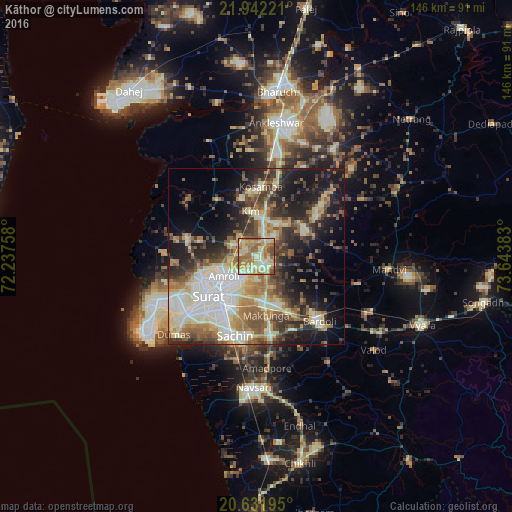
Analysis of Kāthor night lights 2016
Square area 10x10 km:
100  1.14%
1.14%
90-99 23.11%
80-89 24.43%
70-79 17.42%
60-69 18.94%
50-59 10.23%
40-49 4.73%
30-39 0%
20-29 0%
10-19 0%
0-9 0%
1.14%90-99
23.11%80-89
24.43%70-79
17.42%60-69
18.94%50-59
10.23%40-49
4.73%30-39
0%20-29
0%10-19
0%0-9
0%Square area 50x50 km:
100 6.07%
90-99 10.45%
80-89 6.7%
70-79 4.89%
60-69 6.18%
50-59 6.46%
40-49 6.16%
30-39 7.21%
20-29 9.13%
10-19 15.61%
0-9 21.14%
6.07%90-99
10.45%80-89
6.7%70-79
4.89%60-69
6.18%50-59
6.46%40-49
6.16%30-39
7.21%20-29
9.13%10-19
15.61%0-9
21.14%Clear (daylight) street map image can be seen on geolist.org.
Map coordinates:
21° 56' 32" North, 72° 14' 15.3" East
21° 17' 18.7" North, 72° 56' 26.5" East
20° 37' 55" North, 73° 38' 37.8" East
Some cities around Kāthor sort by population:
• Sūrat
15.4 km =9.6 mi,  228°
228°
• Bārdoli
25.5 km =15.8 mi,  136°
136°
• Kosamba
19.4 km =12.1 mi,  5°
5°
• Amroli
11.4 km =7.1 mi,  248°
248°
• Kadod
30 km =18.6 mi,  105°
105°
• Utrān
9.8 km =6.1 mi, 231°
• Olpād
20.3 km =12.6 mi,  285°
285°
• Sachīn
23.2 km =14.4 mi,  195°
195°
1267492 (p: 15,311)
Sources (retrieved 2019-11-25):
» Earth at Night: Flat Maps 2012, 2016