Amroli night lights from space
Night Light of Amroli (Gujarat) from space (India) Src. Average luminocity for 10x10km area is 83.4008% and for 50x50km: 45.0938%.
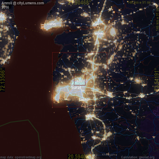
Analysis of Amroli night lights 2016
Square area 10x10 km:
100  29.17%
90-99 32.94%
80-89 9.92%
70-79 3.77%
60-69 5.95%
50-59 4.96%
40-49 5.95%
30-39 5.36%
20-29 1.98%
10-19 0%
0-9 0%
29.17%90-99
32.94%80-89
9.92%70-79
3.77%60-69
5.95%50-59
4.96%40-49
5.95%30-39
5.36%20-29
1.98%10-19
0%0-9
0%Square area 50x50 km:
100 6.92%
90-99 11.31%
80-89 7.02%
70-79 5.06%
60-69 6.52%
50-59 6.69%
40-49 6.52%
30-39 7.28%
20-29 8.95%
10-19 12.05%
0-9 21.68%
6.92%90-99
11.31%80-89
7.02%70-79
5.06%60-69
6.52%50-59
6.69%40-49
6.52%30-39
7.28%20-29
8.95%10-19
12.05%0-9
21.68%Clear (daylight) street map image can be seen on geolist.org.
Map coordinates:
21° 54' 16.8" North, 72° 8' 8.4" East
21° 15' 3" North, 72° 50' 19.6" East
20° 35' 38.7" North, 73° 32' 30.9" East
Some cities around Amroli sort by population:
• Sūrat
6.2 km =3.9 mi,  188°
188°
• Bārdoli
31.6 km =19.6 mi,  116°
116°
• Kosamba
26.5 km =16.5 mi,  27°
27°
• Jalālpur
34.1 km =21.2 mi,  169°
169°
• Kāthor
11.4 km =7.1 mi,  68°
68°
• Utrān
3.5 km =2.2 mi, 123°
• Olpād
13.1 km =8.1 mi,  316°
316°
• Sachīn
18.7 km =11.6 mi, 166°
1278707 (p: 17,082)
Sources (retrieved 2019-11-25):
» Earth at Night: Flat Maps 2012, 2016