Jalālpur night lights from space
Night Light of Jalālpur (Gujarat) from space (India) Src. Average luminocity for 10x10km area is 38.5833% and for 50x50km: 26.6486%.
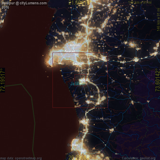
Analysis of Jalālpur night lights 2016
Square area 10x10 km:
 4.56%
4.56%90-99
12.7%80-89
7.94%70-79
1.79%60-69
0.79%50-59
0.99%40-49
6.15%30-39
9.52%20-29
11.31%10-19
22.02%0-9
22.22%Square area 50x50 km:
3.13%90-99
6.41%80-89
4.03%70-79
2.38%60-69
3.72%50-59
4.3%40-49
3.81%30-39
4.57%20-29
6.19%10-19
13.5%0-9
47.96%Clear (daylight) street map image can be seen on geolist.org.
Map coordinates:
21° 36' 15" North, 72° 11' 42.6" East
20° 56' 56.3" North, 72° 53' 53.8" East
20° 17' 27.2" North, 73° 36' 5.1" East
Some cities around Jalālpur sort by population:
• Sūrat
28.4 km =17.6 mi,  345°
345°
• Bilimora
21 km =13 mi,  161°
161°
• Navsāri
2.8 km =1.7 mi,  104°
104°
• Bārdoli
29.4 km =18.3 mi,  48°
48°
• Abrama
10.1 km =6.3 mi,  175°
175°
• Gandevi
18.4 km =11.4 mi,  145°
145°
• Sachīn
15.5 km =9.6 mi, 353°
• Chikhli
27.3 km =17 mi,  141°
141°
1269439 (p: 17,325)
Sources (retrieved 2019-11-25):
» Earth at Night: Flat Maps 2012, 2016