Sultanpur night lights from space
Night Light of Sultanpur (Punjab) from space (India) Src. Average luminocity for 10x10km area is 14.7637% and for 50x50km: 15.972%.
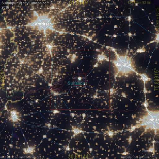
Analysis of Sultanpur night lights 2016
Square area 10x10 km:
 1.47%
1.47%90-99
4.95%80-89
0.55%70-79
0.73%60-69
1.83%50-59
0.73%40-49
1.1%30-39
1.28%20-29
1.65%10-19
4.76%0-9
80.95%Square area 50x50 km:
0.67%90-99
2.02%80-89
1.08%70-79
1.16%60-69
1.49%50-59
2.51%40-49
4.81%30-39
4.07%20-29
6.8%10-19
16.65%0-9
58.74%Clear (daylight) street map image can be seen on geolist.org.
Map coordinates:
31° 48' 50.8" North, 74° 29' 34.4" East
31° 12' 52.8" North, 75° 11' 45.7" East
30° 36' 41.2" North, 75° 53' 56.9" East
Some cities around Sultanpur sort by population:
• Kapūrthala
25.4 km =15.8 mi,  43°
43°
• Patti
32.9 km =20.4 mi,  282°
282°
• Nakodar
28.3 km =17.6 mi,  110°
110°
• Zira
33.6 km =20.9 mi,  215°
215°
• Shāhkot
20 km =12.4 mi,  137°
137°
• Makhu
22.7 km =14.1 mi,  236°
236°
• Kot Īsa Khān
30.3 km =18.8 mi,  190°
190°
• Dhilwan
36.2 km =22.5 mi,  23°
23°
1255488 (p: 16,344)
Sources (retrieved 2019-11-25):
» Earth at Night: Flat Maps 2012, 2016