Shāhkot night lights from space
Night Light of Shāhkot (Punjab) from space (India) Src. Average luminocity for 10x10km area is 18.8535% and for 50x50km: 13.2515%.
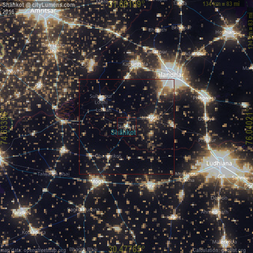
Analysis of Shāhkot night lights 2016
Square area 10x10 km:
 1.65%
1.65%90-99
0.92%80-89
0.73%70-79
0.18%60-69
3.11%50-59
3.66%40-49
6.23%30-39
5.68%20-29
4.95%10-19
17.4%0-9
55.49%Square area 50x50 km:
0.88%90-99
1.48%80-89
0.57%70-79
0.84%60-69
1.78%50-59
2.22%40-49
3.49%30-39
3.28%20-29
4.7%10-19
10.9%0-9
69.87%Clear (daylight) street map image can be seen on geolist.org.
Map coordinates:
31° 40' 55.2" North, 74° 38' 2.3" East
31° 4' 54.2" North, 75° 20' 13.5" East
30° 28' 39.5" North, 76° 2' 24.8" East
Some cities around Shāhkot sort by population:
• Moga
33.8 km =21 mi,  208°
208°
• Kapūrthala
33.4 km =20.8 mi,  7°
7°
• Nakodar
14 km =8.7 mi,  69°
69°
• Jandiāla
28.1 km =17.5 mi, 72°
• Sultanpur
20 km =12.4 mi,  317°
317°
• Nūrmahal
24.5 km =15.2 mi,  86°
86°
• Makhu
32.5 km =20.2 mi,  274°
274°
• Kot Īsa Khān
24.2 km =15 mi,  231°
231°
1256725 (p: 13,577)
Sources (retrieved 2019-11-25):
» Earth at Night: Flat Maps 2012, 2016