Dhilwan night lights from space
Night Light of Dhilwan (Punjab) from space (India) Src. Average luminocity for 10x10km area is 19.25% and for 50x50km: 21.4575%.
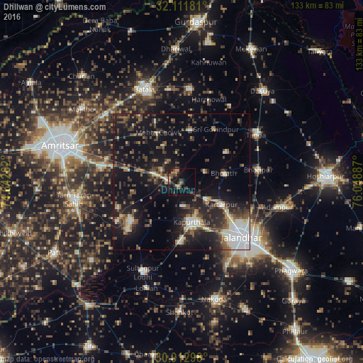
Analysis of Dhilwan night lights 2016
Square area 10x10 km:
 0%
0%90-99
1.22%80-89
1.22%70-79
2.97%60-69
3.32%50-59
2.97%40-49
4.9%30-39
7.17%20-29
4.02%10-19
20.45%0-9
51.75%Square area 50x50 km:
2.45%90-99
3.76%80-89
1.52%70-79
1.32%60-69
2.22%50-59
3.19%40-49
4.98%30-39
4.56%20-29
7.75%10-19
18.01%0-9
50.24%Clear (daylight) street map image can be seen on geolist.org.
Map coordinates:
32° 6' 42.5" North, 74° 38' 33.4" East
31° 30' 51.6" North, 75° 20' 44.7" East
30° 54' 46.7" North, 76° 2' 55.9" East
Some cities around Dhilwan sort by population:
• Jalandhar
30.5 km =19 mi,  133°
133°
• Kapūrthala
15.3 km =9.5 mi,  167°
167°
• Kartārpur
16.5 km =10.3 mi,  118°
118°
• Bhogpur
28.5 km =17.7 mi,  80°
80°
• Bhulath Gharbi
15.7 km =9.8 mi, 78°
• Begowāl
19.8 km =12.3 mi,  56°
56°
• Jandiāla Gurū
30.6 km =19 mi,  279°
279°
• Alāwalpur
30.8 km =19.1 mi,  107°
107°
1272771 (p: 8,447)
Sources (retrieved 2019-11-25):
» Earth at Night: Flat Maps 2012, 2016