Rāīwāla Bara night lights from space
Night Light of Rāīwāla Bara (Uttarakhand) from space (India) Src. Average luminocity for 10x10km area is 43.3788% and for 50x50km: 20.7274%.
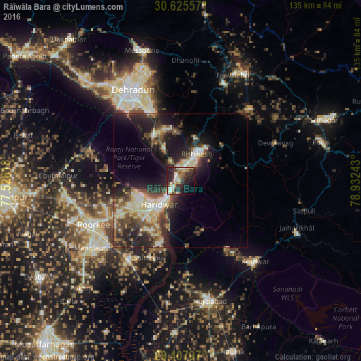
Analysis of Rāīwāla Bara night lights 2016
Square area 10x10 km:
 3.41%
3.41%90-99
12.5%80-89
5.49%70-79
5.87%60-69
3.79%50-59
7.01%40-49
2.65%30-39
8.9%20-29
22.92%10-19
18.56%0-9
8.9%Square area 50x50 km:
1.77%90-99
4.23%80-89
3.26%70-79
2.21%60-69
1.8%50-59
3.29%40-49
3.91%30-39
4.15%20-29
8.34%10-19
11.44%0-9
55.6%Clear (daylight) street map image can be seen on geolist.org.
Map coordinates:
30° 37' 32.1" North, 77° 31' 34.2" East
30° 1' 7.1" North, 78° 13' 45.5" East
29° 24' 28.7" North, 78° 55' 56.7" East
Some cities around Rāīwāla Bara sort by population:
• Haridwar
10.3 km =6.4 mi,  220°
220°
• Rishīkesh
11.6 km =7.2 mi,  31°
31°
• Rāipur
35.2 km =21.9 mi,  337°
337°
• Clement Town
34.5 km =21.4 mi,  322°
322°
• Laksar
34.1 km =21.2 mi,  212°
212°
• Birbhaddar
7.7 km =4.8 mi,  40°
40°
• Sultānpur
31.4 km =19.5 mi,  201°
201°
• Doiwāla
20.6 km =12.8 mi,  328°
328°
1258942 (p: 5,198)
Sources (retrieved 2019-11-25):
» Earth at Night: Flat Maps 2012, 2016