Birbhaddar night lights from space
Night Light of Birbhaddar (Uttarakhand) from space (India) Src. Average luminocity for 10x10km area is 50.9091% and for 50x50km: 19.2673%.
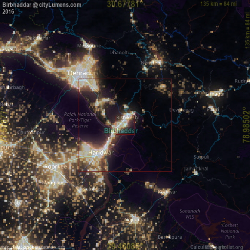
Analysis of Birbhaddar night lights 2016
Square area 10x10 km:
 8.52%
8.52%90-99
15.15%80-89
7.2%70-79
5.11%60-69
3.41%50-59
5.49%40-49
6.06%30-39
9.66%20-29
18.37%10-19
14.77%0-9
6.25%Square area 50x50 km:
1.96%90-99
4.44%80-89
3.45%70-79
1.72%60-69
1.4%50-59
2.9%40-49
3.22%30-39
3.61%20-29
6.38%10-19
10.21%0-9
60.71%Clear (daylight) street map image can be seen on geolist.org.
Map coordinates:
30° 40' 40.1" North, 77° 34' 43.6" East
30° 4' 16.3" North, 78° 16' 54.8" East
29° 27' 39.1" North, 78° 59' 6.1" East
Some cities around Birbhaddar sort by population:
• Dehra Dūn
36.9 km =22.9 mi,  319°
319°
• Haridwar
18 km =11.2 mi,  220°
220°
• Rishīkesh
4.2 km =2.6 mi,  14°
14°
• Rāipur
32.4 km =20.1 mi,  325°
325°
• Clement Town
33.9 km =21.1 mi,  309°
309°
• Sultānpur
38.8 km =24.1 mi,  205°
205°
• Doiwāla
19.8 km =12.3 mi, 306°
• Rāīwāla Bara
7.7 km =4.8 mi, 220°
1275526 (p: 13,058)
Sources (retrieved 2019-11-25):
» Earth at Night: Flat Maps 2012, 2016