Lansdowne night lights from space
Night Light of Lansdowne (Uttarakhand) from space (India) Src. Average luminocity for 10x10km area is 6.3968% and for 50x50km: 1.8116%.
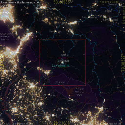
Analysis of Lansdowne night lights 2016
Square area 10x10 km:
 0.99%
0.99%90-99
1.39%80-89
1.59%70-79
0%60-69
1.59%50-59
0%40-49
0%30-39
0.79%20-29
0.79%10-19
0.79%0-9
92.06%Square area 50x50 km:
0.13%90-99
0.21%80-89
0.18%70-79
0.09%60-69
0.27%50-59
0.33%40-49
0.38%30-39
0.33%20-29
0.39%10-19
1.43%0-9
96.26%Clear (daylight) street map image can be seen on geolist.org.
Map coordinates:
30° 26' 59.5" North, 77° 58' 37.3" East
29° 50' 30.6" North, 78° 40' 48.5" East
29° 13' 48.3" North, 79° 22' 59.8" East
Some cities around Lansdowne sort by population:
• Najībābād
41.4 km =25.7 mi,  231°
231°
• Rishīkesh
47.6 km =29.6 mi,  308°
308°
• Kotdwāra
18.6 km =11.6 mi,  235°
235°
• Pauri
35.8 km =22.2 mi,  15°
15°
• Srīnagar
43.5 km =27 mi,  13°
13°
• Kālāgarh Project Colony
41.7 km =25.9 mi,  166°
166°
• Birbhaddar
46.1 km =28.6 mi,  303°
303°
• Rāīwāla Bara
47.7 km =29.6 mi,  294°
294°
1265074 (p: 8,198)
Sources (retrieved 2019-11-25):
» Earth at Night: Flat Maps 2012, 2016