Sirmaur night lights from space
Night Light of Sirmaur (Madhya Pradesh) from space (India) Src. Average luminocity for 10x10km area is 14.4867% and for 50x50km: 7.6434%.
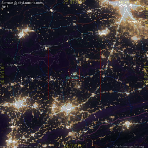
Analysis of Sirmaur night lights 2016
Square area 10x10 km:
 0.38%
0.38%90-99
1.52%80-89
0.57%70-79
1.14%60-69
2.84%50-59
2.46%40-49
0.95%30-39
4.55%20-29
7.58%10-19
11.36%0-9
66.67%Square area 50x50 km:
0.08%90-99
0.32%80-89
0.38%70-79
0.47%60-69
0.57%50-59
1.16%40-49
1.99%30-39
3.33%20-29
4.2%10-19
6.68%0-9
80.81%Clear (daylight) street map image can be seen on geolist.org.
Map coordinates:
25° 28' 22.5" North, 80° 39' 40.9" East
24° 50' 11.3" North, 81° 21' 52.1" East
24° 11' 48.3" North, 82° 4' 3.4" East
Some cities around Sirmaur sort by population:
• Rewa
34.6 km =21.5 mi,  192°
192°
• Teonthar
32.3 km =20.1 mi,  59°
59°
• Mānikpur
36.5 km =22.7 mi,  313°
313°
• Simaria
21.9 km =13.6 mi,  257°
257°
• Kotwa
22.1 km =13.7 mi,  348°
348°
• Mangawān
26.3 km =16.3 mi,  135°
135°
• Baikunthpur
12.9 km =8 mi,  159°
159°
• Sohāgi
37.1 km =23.1 mi, 64°
1256072 (p: 11,812)
Sources (retrieved 2019-11-25):
» Earth at Night: Flat Maps 2012, 2016