Simaria night lights from space
Night Light of Simaria (Madhya Pradesh) from space (India) Src. Average luminocity for 10x10km area is 11.0322% and for 50x50km: 9.6541%.
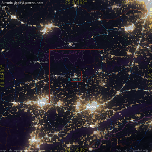
Analysis of Simaria night lights 2016
Square area 10x10 km:
 0.38%
0.38%90-99
0.38%80-89
0.19%70-79
1.33%60-69
0.19%50-59
3.03%40-49
3.41%30-39
6.06%20-29
3.6%10-19
5.3%0-9
76.14%Square area 50x50 km:
0.33%90-99
0.52%80-89
0.55%70-79
0.73%60-69
1.01%50-59
2%40-49
2.9%30-39
3.95%20-29
5.23%10-19
7.54%0-9
75.25%Clear (daylight) street map image can be seen on geolist.org.
Map coordinates:
25° 25' 53.8" North, 80° 26' 56" East
24° 47' 41.9" North, 81° 9' 7.2" East
24° 9' 18.1" North, 81° 51' 18.5" East
Some cities around Simaria sort by population:
• Rewa
32.4 km =20.1 mi,  154°
154°
• Mānikpur
30 km =18.6 mi,  349°
349°
• Kotwa
31.2 km =19.4 mi,  32°
32°
• Sirmaur
21.9 km =13.6 mi,  77°
77°
• Baikunthpur
27.1 km =16.8 mi,  106°
106°
• Kothi
38.1 km =23.7 mi,  262°
262°
• Kotār
20.4 km =12.7 mi,  238°
238°
• Madhogarh
35.4 km =22 mi,  223°
223°
1256251 (p: 14,045)
Sources (retrieved 2019-11-25):
» Earth at Night: Flat Maps 2012, 2016