Sohāgi night lights from space
Night Light of Sohāgi (Madhya Pradesh) from space (India) Src. Average luminocity for 10x10km area is 26.5947% and for 50x50km: 13.3748%.
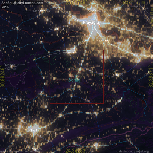
Analysis of Sohāgi night lights 2016
Square area 10x10 km:
 0.76%
0.76%90-99
1.14%80-89
2.08%70-79
2.65%60-69
5.3%50-59
7.39%40-49
5.87%30-39
2.27%20-29
11.55%10-19
48.86%0-9
12.12%Square area 50x50 km:
0.93%90-99
0.92%80-89
0.64%70-79
1.17%60-69
1.36%50-59
2.69%40-49
3.3%30-39
3.77%20-29
6.91%10-19
13.07%0-9
65.24%Clear (daylight) street map image can be seen on geolist.org.
Map coordinates:
25° 37' 3" North, 80° 59' 32.9" East
24° 58' 54.5" North, 81° 41' 44.1" East
24° 20' 34.2" North, 82° 23' 55.4" East
Some cities around Sohāgi sort by population:
• Mauganj
39.3 km =24.4 mi,  152°
152°
• Teonthar
5.4 km =3.4 mi,  270°
270°
• Shankargarh
23.6 km =14.7 mi,  340°
340°
• Kotwa
38.3 km =23.8 mi,  278°
278°
• Mangawān
38 km =23.6 mi,  203°
203°
• Sirmaur
37.1 km =23.1 mi,  244°
244°
• Baikunthpur
40.4 km =25.1 mi,  225°
225°
• Naīgarhi
23.2 km =14.4 mi,  158°
158°
1255887 (p: 9,009)
Sources (retrieved 2019-11-25):
» Earth at Night: Flat Maps 2012, 2016