Mangawān night lights from space
Night Light of Mangawān (Madhya Pradesh) from space (India) Src. Average luminocity for 10x10km area is 18.5417% and for 50x50km: 14.4661%.
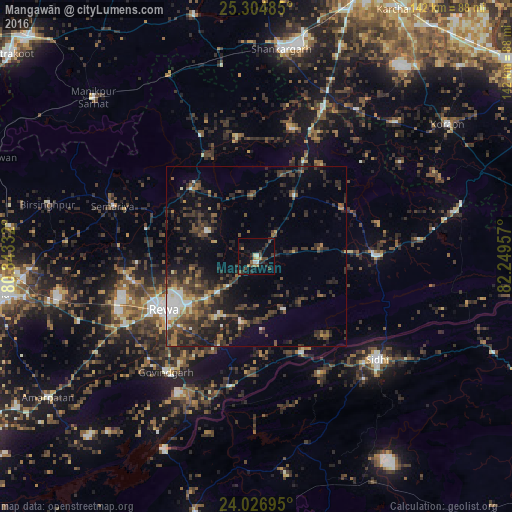
Analysis of Mangawān night lights 2016
Square area 10x10 km:
 0.4%
0.4%90-99
2.38%80-89
1.19%70-79
1.19%60-69
4.37%50-59
0.79%40-49
5.36%30-39
5.36%20-29
5.95%10-19
9.92%0-9
63.1%Square area 50x50 km:
1.1%90-99
1.33%80-89
0.97%70-79
0.92%60-69
1.63%50-59
2.59%40-49
4.11%30-39
5.07%20-29
6.34%10-19
8.82%0-9
67.12%Clear (daylight) street map image can be seen on geolist.org.
Map coordinates:
25° 18' 17.5" North, 80° 50' 36" East
24° 40' 3.1" North, 81° 32' 47.2" East
24° 1' 37" North, 82° 14' 58.5" East
Some cities around Mangawān sort by population:
• Rewa
29.8 km =18.5 mi,  239°
239°
• Mauganj
33 km =20.5 mi,  90°
90°
• Teonthar
36.3 km =22.6 mi,  15°
15°
• Chorhat
29.5 km =18.3 mi,  155°
155°
• Gurh
18.9 km =11.7 mi,  194°
194°
• Sirmaur
26.3 km =16.3 mi,  315°
315°
• Baikunthpur
15.3 km =9.5 mi,  295°
295°
• Naīgarhi
26.9 km =16.7 mi,  60°
60°
1263764 (p: 12,503)
Sources (retrieved 2019-11-25):
» Earth at Night: Flat Maps 2012, 2016