Kotwa night lights from space
Night Light of Kotwa (Madhya Pradesh) from space (India) Src. Average luminocity for 10x10km area is 1.1458% and for 50x50km: 3.3069%.
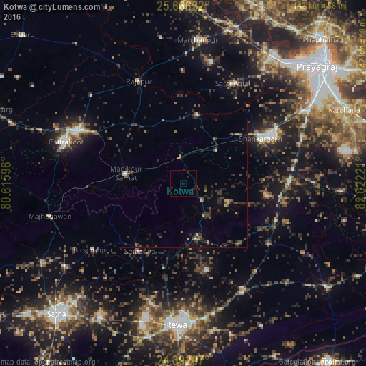
Analysis of Kotwa night lights 2016
Square area 10x10 km:
 0%
0%90-99
0%80-89
0%70-79
0%60-69
0%50-59
0%40-49
0%30-39
0.38%20-29
2.08%10-19
2.46%0-9
95.08%Square area 50x50 km:
0.05%90-99
0.19%80-89
0.18%70-79
0.22%60-69
0.37%50-59
0.55%40-49
0.73%30-39
1.49%20-29
1.85%10-19
1.52%0-9
92.85%Clear (daylight) street map image can be seen on geolist.org.
Map coordinates:
25° 39' 58.4" North, 80° 36' 57.5" East
25° 1' 50.9" North, 81° 19' 8.7" East
24° 23' 31.5" North, 82° 1' 20" East
Some cities around Kotwa sort by population:
• Teonthar
33 km =20.5 mi,  99°
99°
• Mānikpur
22.4 km =13.9 mi,  278°
278°
• Shankargarh
34.4 km =21.4 mi,  60°
60°
• Simaria
31.2 km =19.4 mi,  212°
212°
• Rājāpur
43.1 km =26.8 mi,  336°
336°
• Sirmaur
22.1 km =13.7 mi,  168°
168°
• Baikunthpur
34.9 km =21.7 mi,  164°
164°
• Sohāgi
38.3 km =23.8 mi, 98°
1265901 (p: 13,916)
Sources (retrieved 2019-11-25):
» Earth at Night: Flat Maps 2012, 2016