Mānikpur night lights from space
Night Light of Mānikpur (Uttar Pradesh) from space (India) Src. Average luminocity for 10x10km area is 5.7254% and for 50x50km: 4.1055%.
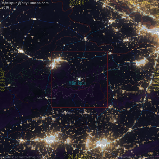
Analysis of Mānikpur night lights 2016
Square area 10x10 km:
 0.76%
0.76%90-99
1.33%80-89
0.19%70-79
0.76%60-69
0%50-59
1.14%40-49
1.14%30-39
2.27%20-29
0%10-19
0.76%0-9
91.67%Square area 50x50 km:
0.52%90-99
0.74%80-89
0.21%70-79
0.34%60-69
0.46%50-59
0.74%40-49
0.77%30-39
0.91%20-29
1.33%10-19
2.79%0-9
91.17%Clear (daylight) street map image can be seen on geolist.org.
Map coordinates:
25° 41' 46" North, 80° 23' 47.4" East
25° 3' 39" North, 81° 5' 58.6" East
24° 25' 20.1" North, 81° 48' 9.9" East
Some cities around Mānikpur sort by population:
• Simaria
30 km =18.6 mi,  169°
169°
• Rājāpur
36.7 km =22.8 mi,  8°
8°
• Kotwa
22.4 km =13.9 mi,  98°
98°
• Sirmaur
36.5 km =22.7 mi,  133°
133°
• Baikunthpur
48.5 km =30.1 mi,  139°
139°
• Kothi
47.2 km =29.3 mi,  223°
223°
• Kotār
42.1 km =26.2 mi,  196°
196°
• Oran
49.6 km =30.8 mi,  313°
313°
1263715 (p: 14,415)
Sources (retrieved 2019-11-25):
» Earth at Night: Flat Maps 2012, 2016