Simga night lights from space
Night Light of Simga (Chhattisgarh) from space (India) Src. Average luminocity for 10x10km area is 29.3902% and for 50x50km: 26.6812%.
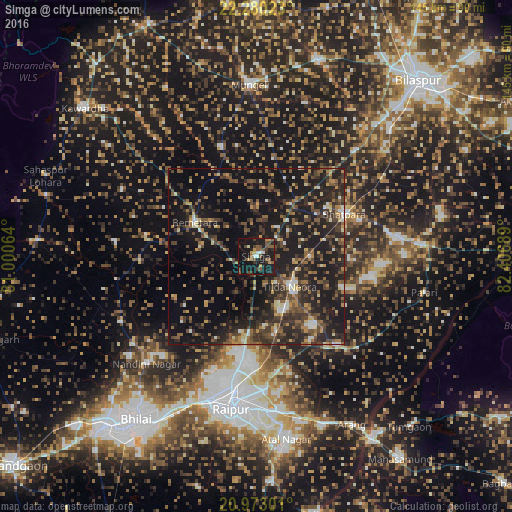
Analysis of Simga night lights 2016
Square area 10x10 km:
 1.14%
1.14%90-99
2.84%80-89
1.33%70-79
4.55%60-69
1.33%50-59
10.42%40-49
5.87%30-39
5.68%20-29
10.61%10-19
47.73%0-9
8.52%Square area 50x50 km:
1.21%90-99
2.04%80-89
2.04%70-79
3.17%60-69
3.09%50-59
5.7%40-49
6.76%30-39
7.59%20-29
12.23%10-19
29.95%0-9
26.22%Clear (daylight) street map image can be seen on geolist.org.
Map coordinates:
22° 16' 48.8" North, 81° 0' 2.3" East
21° 37' 41.2" North, 81° 42' 13.5" East
20° 58' 22.8" North, 82° 24' 24.8" East
Some cities around Simga sort by population:
• Raipur
44.5 km =27.7 mi,  189°
189°
• Bhilai
54.6 km =33.9 mi,  211°
211°
• Bhātāpāra
27.8 km =17.3 mi,  64°
64°
• Kumhāri
44.6 km =27.7 mi, 205°
• Mungeli
48.7 km =30.3 mi,  357°
357°
• Baloda Bāzār
47.3 km =29.4 mi,  86°
86°
• Bemetāra
20 km =12.4 mi,  299°
299°
• Bhatgaon
53.2 km =33.1 mi,  180°
180°
1256245 (p: 12,944)
Sources (retrieved 2019-11-25):
» Earth at Night: Flat Maps 2012, 2016