Kotār night lights from space
Night Light of Kotār (Madhya Pradesh) from space (India) Src. Average luminocity for 10x10km area is 10.0218% and for 50x50km: 19.5914%.
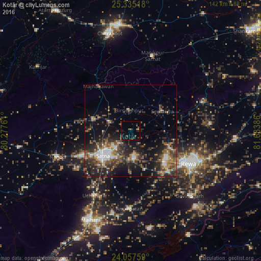
Analysis of Kotār night lights 2016
Square area 10x10 km:
 0%
0%90-99
0%80-89
0.79%70-79
0.4%60-69
1.79%50-59
2.18%40-49
3.37%30-39
1.98%20-29
2.58%10-19
6.55%0-9
80.36%Square area 50x50 km:
2%90-99
2.53%80-89
1.3%70-79
1.9%60-69
2.8%50-59
4.33%40-49
4.57%30-39
5.12%20-29
7.55%10-19
11.65%0-9
56.25%Clear (daylight) street map image can be seen on geolist.org.
Map coordinates:
25° 20' 6.6" North, 80° 16' 39.4" East
24° 41' 52.9" North, 80° 58' 50.6" East
24° 3' 27.3" North, 81° 41' 1.9" East
Some cities around Kotār sort by population:
• Satna
20.5 km =12.7 mi,  229°
229°
• Rewa
36.5 km =22.7 mi,  120°
120°
• Nāgod
42.2 km =26.2 mi,  250°
250°
• Mānikpur
42.1 km =26.2 mi,  16°
16°
• Simaria
20.4 km =12.7 mi,  58°
58°
• Sirmaur
41.7 km =25.9 mi,  68°
68°
• Kothi
21.4 km =13.3 mi,  286°
286°
• Madhogarh
16.5 km =10.3 mi,  205°
205°
1266028 (p: 6,953)
Sources (retrieved 2019-11-25):
» Earth at Night: Flat Maps 2012, 2016