Nūrmahal night lights from space
Night Light of Nūrmahal (Punjab) from space (India) Src. Average luminocity for 10x10km area is 18.6484% and for 50x50km: 24.451%.
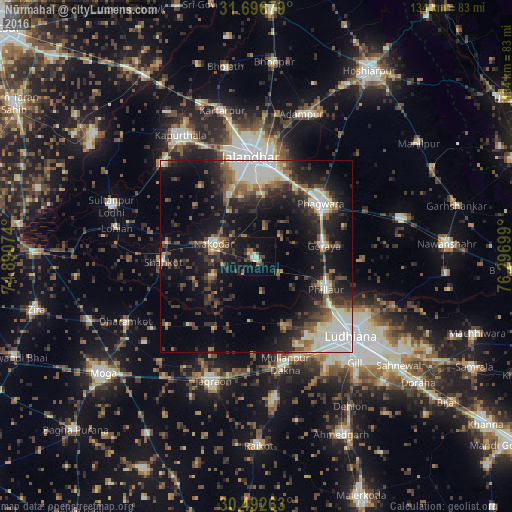
Analysis of Nūrmahal night lights 2016
Square area 10x10 km:
 0.73%
0.73%90-99
2.93%80-89
1.83%70-79
0.18%60-69
3.3%50-59
2.38%40-49
3.66%30-39
3.48%20-29
4.03%10-19
21.61%0-9
55.86%Square area 50x50 km:
3.89%90-99
4.87%80-89
1.88%70-79
1.54%60-69
2.63%50-59
3.58%40-49
4.49%30-39
4.8%20-29
7.78%10-19
16.6%0-9
47.94%Clear (daylight) street map image can be seen on geolist.org.
Map coordinates:
31° 41' 48.4" North, 74° 53' 26.7" East
31° 5' 47.8" North, 75° 35' 37.9" East
30° 29' 33.5" North, 76° 17' 49.2" East
Some cities around Nūrmahal sort by population:
• Ludhiāna
32.2 km =20 mi,  129°
129°
• Jalandhar
25.5 km =15.8 mi,  356°
356°
• Phagwāra
22.3 km =13.9 mi,  50°
50°
• Jagraon
36.2 km =22.5 mi,  198°
198°
• Nakodar
11.8 km =7.3 mi,  286°
286°
• Jandiāla
7.3 km =4.5 mi,  17°
17°
• Phillaur
20.7 km =12.9 mi,  114°
114°
• Shāhkot
24.5 km =15.2 mi,  266°
266°
1261124 (p: 13,154)
Sources (retrieved 2019-11-25):
» Earth at Night: Flat Maps 2012, 2016