Sāyla night lights from space
Night Light of Sāyla (Gujarat) from space (India) Src. Average luminocity for 10x10km area is 19.947% and for 50x50km: 8.3843%.
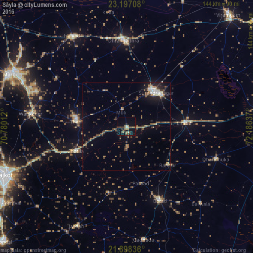
Analysis of Sāyla night lights 2016
Square area 10x10 km:
 0%
0%90-99
2.27%80-89
0.76%70-79
3.22%60-69
3.79%50-59
5.68%40-49
2.65%30-39
4.17%20-29
3.22%10-19
20.83%0-9
53.41%Square area 50x50 km:
0.49%90-99
0.84%80-89
0.73%70-79
0.94%60-69
1.29%50-59
1.8%40-49
1.26%30-39
1.95%20-29
2.08%10-19
4.1%0-9
84.5%Clear (daylight) street map image can be seen on geolist.org.
Map coordinates:
23° 11' 49.5" North, 70° 46' 48.4" East
22° 32' 57.3" North, 71° 28' 59.7" East
21° 53' 54.1" North, 72° 11' 10.9" East
Some cities around Sāyla sort by population:
• Surendranagar
26.1 km =16.2 mi,  40°
40°
• Botād
46.3 km =28.8 mi,  155°
155°
• Thān
29.3 km =18.2 mi,  275°
275°
• Limbdi
33.7 km =20.9 mi,  87°
87°
• Chotila
32.6 km =20.3 mi,  244°
244°
• Lakhtar
46.4 km =28.8 mi, 42°
• Vinchia
39.2 km =24.4 mi,  195°
195°
• Pāliyād
33.4 km =20.8 mi,  166°
166°
1256929 (p: 15,376)
Sources (retrieved 2019-11-25):
» Earth at Night: Flat Maps 2012, 2016