Chotila night lights from space
Night Light of Chotila (Gujarat) from space (India) Src. Average luminocity for 10x10km area is 26.0492% and for 50x50km: 8.7696%.
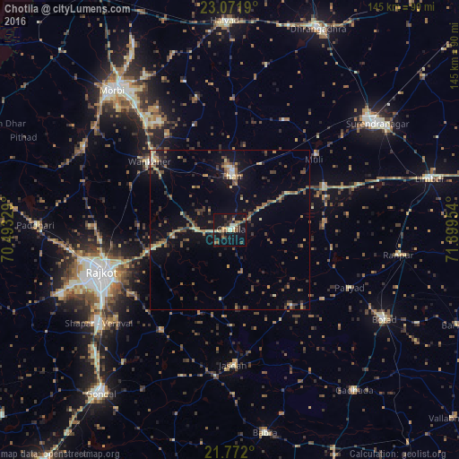
Analysis of Chotila night lights 2016
Square area 10x10 km:
 0.57%
0.57%90-99
3.79%80-89
4.17%70-79
4.55%60-69
1.89%50-59
5.49%40-49
1.7%30-39
7.01%20-29
3.79%10-19
40.72%0-9
26.33%Square area 50x50 km:
0.13%90-99
0.55%80-89
1.1%70-79
1.19%60-69
1.38%50-59
1.68%40-49
1.64%30-39
2.19%20-29
1.69%10-19
6.67%0-9
81.78%Clear (daylight) street map image can be seen on geolist.org.
Map coordinates:
23° 4' 18.8" North, 70° 29' 35.8" East
22° 25' 24.5" North, 71° 11' 47.1" East
21° 46' 19.2" North, 71° 53' 58.3" East
Some cities around Chotila sort by population:
• Rājkot
44 km =27.3 mi,  250°
250°
• Wānkāner
33.4 km =20.8 mi,  308°
308°
• Jasdan
43 km =26.7 mi,  178°
178°
• Thān
16.8 km =10.4 mi,  1°
1°
• Sāyla
32.6 km =20.3 mi,  64°
64°
• Vinchia
30.3 km =18.8 mi,  141°
141°
• Pāliyād
41.7 km =25.9 mi,  116°
116°
• Tankāra
52.7 km =32.7 mi,  299°
299°
1273960 (p: 15,197)
Sources (retrieved 2019-11-25):
» Earth at Night: Flat Maps 2012, 2016