Santokhgarh night lights from space
Night Light of Santokhgarh (Himachal Pradesh) from space (India) Src. Average luminocity for 10x10km area is 41.4808% and for 50x50km: 8.7394%.
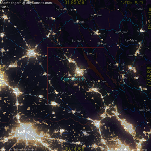
Analysis of Santokhgarh night lights 2016
Square area 10x10 km:
 2.62%
2.62%90-99
11.89%80-89
7.17%70-79
3.15%60-69
4.9%50-59
4.72%40-49
6.99%30-39
5.42%20-29
12.59%10-19
35.66%0-9
4.9%Square area 50x50 km:
0.31%90-99
1.35%80-89
0.96%70-79
0.6%60-69
1.33%50-59
1.26%40-49
1.69%30-39
2.02%20-29
2.51%10-19
7.96%0-9
80.01%Clear (daylight) street map image can be seen on geolist.org.
Map coordinates:
31° 57' 2.1" North, 75° 36' 52.7" East
31° 21' 7.4" North, 76° 19' 3.9" East
30° 44' 58.8" North, 77° 1' 15.2" East
Some cities around Santokhgarh sort by population:
• Nangal
6.9 km =4.3 mi,  52°
52°
• Nawanshahr
31.7 km =19.7 mi,  217°
217°
• Banga
35.6 km =22.1 mi,  239°
239°
• Bālāchor
32.4 km =20.1 mi,  182°
182°
• Una
13.4 km =8.3 mi,  339°
339°
• Garhshankar
22.6 km =14 mi,  227°
227°
• Anandpur
21.6 km =13.4 mi,  125°
125°
• Nūrpur Kalān
25.9 km =16.1 mi,  142°
142°
1257326 (p: 8,877)
Sources (retrieved 2019-11-25):
» Earth at Night: Flat Maps 2012, 2016