Bālāchor night lights from space
Night Light of Bālāchor (Punjab) from space (India) Src. Average luminocity for 10x10km area is 8.4725% and for 50x50km: 12.0695%.
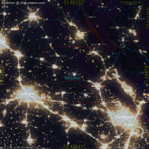
Analysis of Bālāchor night lights 2016
Square area 10x10 km:
 0.37%
0.37%90-99
1.47%80-89
1.1%70-79
0.73%60-69
1.28%50-59
1.65%40-49
0.37%30-39
1.47%20-29
4.03%10-19
0%0-9
87.55%Square area 50x50 km:
0.77%90-99
1.85%80-89
0.94%70-79
1.03%60-69
1.74%50-59
1.74%40-49
2.36%30-39
2.63%20-29
3.77%10-19
10.24%0-9
72.93%Clear (daylight) street map image can be seen on geolist.org.
Map coordinates:
31° 39' 39.7" North, 75° 35' 54.7" East
31° 3' 38.2" North, 76° 18' 6" East
30° 27' 23.1" North, 77° 0' 17.2" East
Some cities around Bālāchor sort by population:
• Ropar
23.8 km =14.8 mi,  115°
115°
• Nawanshahr
19 km =11.8 mi,  291°
291°
• Māchhīwāra
18.8 km =11.7 mi,  210°
210°
• Samrāla
27 km =16.8 mi,  202°
202°
• Garhshankar
23 km =14.3 mi,  318°
318°
• Rāhon
17.4 km =10.8 mi,  267°
267°
• Nūrpur Kalān
20.9 km =13 mi,  55°
55°
• Khamānon Kalān
27.5 km =17.1 mi,  169°
169°
1277666 (p: 19,166)
Sources (retrieved 2019-11-25):
» Earth at Night: Flat Maps 2012, 2016