Una night lights from space
Night Light of Una (Himachal Pradesh) from space (India) Src. Average luminocity for 10x10km area is 24.6836% and for 50x50km: 7.6091%.
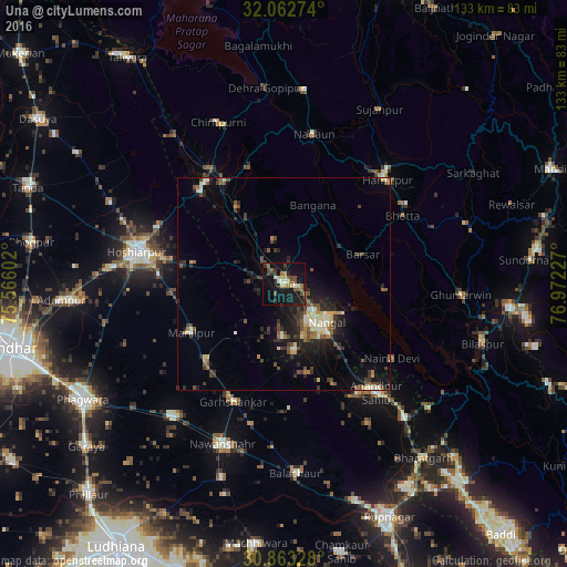
Analysis of Una night lights 2016
Square area 10x10 km:
 0.7%
0.7%90-99
3.15%80-89
3.67%70-79
1.22%60-69
4.2%50-59
3.67%40-49
6.29%30-39
4.55%20-29
5.07%10-19
37.06%0-9
30.42%Square area 50x50 km:
0.25%90-99
1.26%80-89
0.82%70-79
0.61%60-69
0.89%50-59
1.12%40-49
1.7%30-39
1.62%20-29
2.59%10-19
6.31%0-9
82.83%Clear (daylight) street map image can be seen on geolist.org.
Map coordinates:
32° 3' 45.9" North, 75° 33' 57.7" East
31° 27' 53.7" North, 76° 16' 8.9" East
30° 51' 47.8" North, 76° 58' 20.2" East
Some cities around Una sort by population:
• Hoshiārpur
34.7 km =21.6 mi,  283°
283°
• Nangal
13.1 km =8.1 mi,  129°
129°
• Hamīrpur
34.4 km =21.4 mi,  44°
44°
• Banga
40.3 km =25 mi,  220°
220°
• Garhshankar
30.3 km =18.8 mi,  203°
203°
• Anandpur
33.5 km =20.8 mi,  138°
138°
• Nūrpur Kalān
38.9 km =24.2 mi,  148°
148°
• Santokhgarh
13.4 km =8.3 mi,  159°
159°
1253782 (p: 17,569)
Sources (retrieved 2019-11-25):
» Earth at Night: Flat Maps 2012, 2016