Anandpur night lights from space
Night Light of Anandpur (Punjab) from space (India) Src. Average luminocity for 10x10km area is 27.3278% and for 50x50km: 11.8277%.
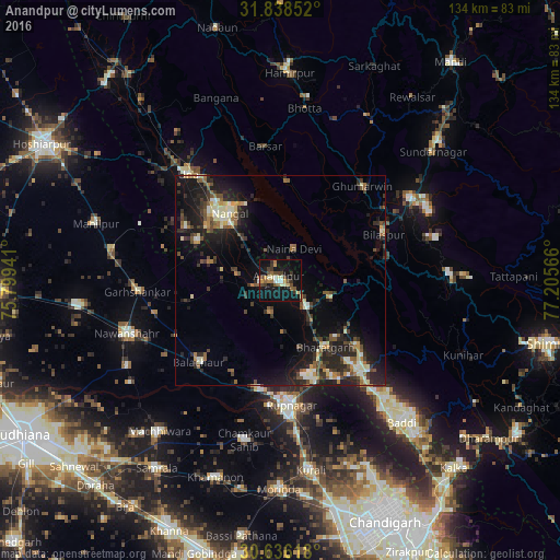
Analysis of Anandpur night lights 2016
Square area 10x10 km:
 1.83%
1.83%90-99
4.03%80-89
3.3%70-79
2.93%60-69
4.21%50-59
3.66%40-49
6.78%30-39
5.31%20-29
1.65%10-19
43.22%0-9
23.08%Square area 50x50 km:
0.51%90-99
2.1%80-89
1.27%70-79
0.95%60-69
1.51%50-59
1.75%40-49
2.19%30-39
2.69%20-29
4.46%10-19
10.37%0-9
72.2%Clear (daylight) street map image can be seen on geolist.org.
Map coordinates:
31° 50' 18.7" North, 75° 47' 57.9" East
31° 14' 21.3" North, 76° 30' 9.1" East
30° 38' 10.2" North, 77° 12' 20.4" East
Some cities around Anandpur sort by population:
• Ropar
30.1 km =18.7 mi,  175°
175°
• Nangal
20.6 km =12.8 mi,  324°
324°
• Bālāchor
27.6 km =17.1 mi,  223°
223°
• Bilaspur
26.2 km =16.3 mi,  67°
67°
• Nālāgarh
30.4 km =18.9 mi,  136°
136°
• Nūrpur Kalān
8.3 km =5.2 mi,  192°
192°
• Santokhgarh
21.6 km =13.4 mi,  305°
305°
• Ghumārwīn
30.2 km =18.8 mi,  41°
41°
1278676 (p: 15,229)
Sources (retrieved 2019-11-25):
» Earth at Night: Flat Maps 2012, 2016