Banga night lights from space
Night Light of Banga (Punjab) from space (India) Src. Average luminocity for 10x10km area is 15.1612% and for 50x50km: 11.0585%.
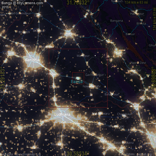
Analysis of Banga night lights 2016
Square area 10x10 km:
 0.55%
0.55%90-99
4.4%80-89
1.65%70-79
0%60-69
0.92%50-59
1.28%40-49
2.56%30-39
4.95%20-29
4.4%10-19
2.75%0-9
76.56%Square area 50x50 km:
0.56%90-99
1.94%80-89
0.88%70-79
0.79%60-69
1.36%50-59
1.7%40-49
2.33%30-39
2.73%20-29
4.11%10-19
8.53%0-9
75.05%Clear (daylight) street map image can be seen on geolist.org.
Map coordinates:
31° 47' 18" North, 75° 17' 30.6" East
31° 11' 19.5" North, 75° 59' 41.8" East
30° 35' 7.2" North, 76° 41' 53.1" East
Some cities around Banga sort by population:
• Ludhiāna
33.6 km =20.9 mi,  203°
203°
• Phagwāra
21.4 km =13.3 mi,  280°
280°
• Nawanshahr
13.6 km =8.5 mi,  121°
121°
• Phillaur
27.1 km =16.8 mi,  225°
225°
• Bālāchor
32.5 km =20.2 mi, 116°
• Garhshankar
14.2 km =8.8 mi,  78°
78°
• Rāhon
19.2 km =11.9 mi,  141°
141°
• Santokhgarh
35.6 km =22.1 mi,  59°
59°
1277338 (p: 19,234)
Sources (retrieved 2019-11-25):
» Earth at Night: Flat Maps 2012, 2016