Sangariā night lights from space
Night Light of Sangariā (Rajasthan) from space (India) Src. Average luminocity for 10x10km area is 8.4762% and for 50x50km: 3.951%.
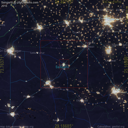

Analysis of Sangariā night lights 2016
Square area 10x10 km:
 1.19%
1.19%90-99
1.19%80-89
0.79%70-79
1.59%60-69
0.79%50-59
0.79%40-49
0.79%30-39
0.4%20-29
1.59%10-19
2.78%0-9
88.1%Square area 50x50 km:
0.11%90-99
0.69%80-89
0.49%70-79
0.34%60-69
0.55%50-59
0.59%40-49
0.8%30-39
0.76%20-29
0.75%10-19
2.39%0-9
92.54%Clear (daylight) street map image can be seen on geolist.org.
Map coordinates:
30° 24' 25.7" North, 73° 45' 49.4" East
29° 47' 55.9" North, 74° 28' 0.6" East
29° 11' 12.7" North, 75° 10' 11.9" East
Some cities around Sangariā sort by population:
• Hanumāngarh
27.5 km =17.1 mi,  208°
208°
• Abohar
46.5 km =28.9 mi,  325°
325°
• Malaut
45.9 km =28.5 mi,  1°
1°
• Dabwāli
31 km =19.3 mi,  57°
57°
• Giddarbāha
48.5 km =30.1 mi,  23°
23°
• Ellenabad
42.8 km =26.6 mi,  153°
153°
• Kālānwāli
48.9 km =30.4 mi,  85°
85°
• Rānia
47 km =29.2 mi,  130°
130°
1257429 (p: 38,638)
Sources (retrieved 2019-11-25):
» Earth at Night: Flat Maps 2012, 2016