Sabāthu night lights from space
Night Light of Sabāthu (Himachal Pradesh) from space (India) Src. Average luminocity for 10x10km area is 3.5696% and for 50x50km: 16.2042%.
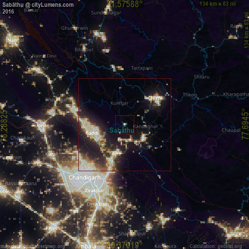
Analysis of Sabāthu night lights 2016
Square area 10x10 km:
 0.37%
0.37%90-99
0.37%80-89
0%70-79
0%60-69
0.73%50-59
0%40-49
0.73%30-39
0.73%20-29
0%10-19
1.1%0-9
95.97%Square area 50x50 km:
1.64%90-99
3.08%80-89
2.82%70-79
1.47%60-69
1.82%50-59
2.02%40-49
2.69%30-39
2.61%20-29
5.24%10-19
12.07%0-9
64.55%Clear (daylight) street map image can be seen on geolist.org.
Map coordinates:
31° 34' 33.2" North, 76° 17' 17.7" East
30° 58' 29.8" North, 76° 59' 28.9" East
30° 22' 12.7" North, 77° 41' 40.2" East
Some cities around Sabāthu sort by population:
• Shimla
22 km =13.7 mi,  49°
49°
• Solan
13.4 km =8.3 mi,  123°
123°
• Kālka
15.8 km =9.8 mi,  197°
197°
• Pinjaur
20.8 km =12.9 mi, 199°
• Baddi
19.2 km =11.9 mi,  264°
264°
• Nālāgarh
26.6 km =16.5 mi,  286°
286°
• Parwanoo
15.6 km =9.7 mi,  190°
190°
• Kasauli
8.8 km =5.5 mi, 195°
1257919 (p: 6,691)
Sources (retrieved 2019-11-25):
» Earth at Night: Flat Maps 2012, 2016