Nālāgarh night lights from space
Night Light of Nālāgarh (Himachal Pradesh) from space (India) Src. Average luminocity for 10x10km area is 42.7857% and for 50x50km: 19.9955%.
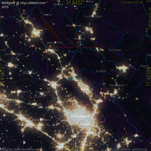
Analysis of Nālāgarh night lights 2016
Square area 10x10 km:
 2.38%
2.38%90-99
13.19%80-89
6.59%70-79
2.56%60-69
7.88%50-59
2.56%40-49
4.58%30-39
11.36%20-29
17.95%10-19
21.79%0-9
9.16%Square area 50x50 km:
1.55%90-99
3.51%80-89
2.69%70-79
1.65%60-69
2.26%50-59
2.52%40-49
3.57%30-39
4.61%20-29
8.5%10-19
17.69%0-9
51.45%Clear (daylight) street map image can be seen on geolist.org.
Map coordinates:
31° 38' 31.9" North, 76° 1' 11" East
31° 2' 30" North, 76° 43' 22.3" East
30° 26' 14.5" North, 77° 25' 33.5" East
Some cities around Nālāgarh sort by population:
• Ropar
20.3 km =12.6 mi,  246°
246°
• Kālka
30.6 km =19 mi,  137°
137°
• Baddi
11.4 km =7.1 mi, 144°
• Anandpur
30.4 km =18.9 mi,  316°
316°
• Bilaspur
32.2 km =20 mi,  5°
5°
• Nūrpur Kalān
26.7 km =16.6 mi,  301°
301°
• Sabāthu
26.6 km =16.5 mi,  106°
106°
• Kasauli
28.1 km =17.5 mi,  124°
124°
1262083 (p: 10,249)
Sources (retrieved 2019-11-25):
» Earth at Night: Flat Maps 2012, 2016