Solan night lights from space
Night Light of Solan (Himachal Pradesh) from space (India) Src. Average luminocity for 10x10km area is 23.5507% and for 50x50km: 11.1524%.

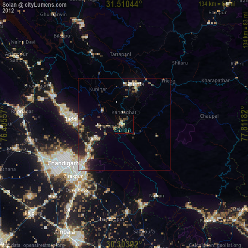
Analysis of Solan night lights 2016
Square area 10x10 km:
 1.92%
1.92%90-99
3.85%80-89
1.22%70-79
2.1%60-69
5.24%50-59
4.72%40-49
3.32%30-39
4.02%20-29
2.8%10-19
29.37%0-9
41.43%Square area 50x50 km:
1%90-99
1.84%80-89
1.48%70-79
1.23%60-69
1.6%50-59
1.7%40-49
2.25%30-39
1.98%20-29
3.24%10-19
8.02%0-9
75.67%Clear (daylight) street map image can be seen on geolist.org.
Map coordinates:
31° 30' 37.6" North, 76° 24' 20.1" East
30° 54' 32.7" North, 77° 6' 31.3" East
30° 18' 14.1" North, 77° 48' 42.6" East
Some cities around Solan sort by population:
• Panchkula
34.3 km =21.3 mi,  225°
225°
• Shimla
22.4 km =13.9 mi,  14°
14°
• Kālka
17.8 km =11.1 mi,  244°
244°
• Pinjaur
21.9 km =13.6 mi, 235°
• Baddi
30.7 km =19.1 mi,  280°
280°
• Parwanoo
16.2 km =10.1 mi, 240°
• Sabāthu
13.4 km =8.3 mi,  303°
303°
• Kasauli
13.7 km =8.5 mi,  265°
265°
1255850 (p: 40,283)
Sources (retrieved 2019-11-25):
» Earth at Night: Flat Maps 2012, 2016