Parwanoo night lights from space
Night Light of Parwanoo (Himachal Pradesh) from space (India) Src. Average luminocity for 10x10km area is 37.5559% and for 50x50km: 29.2754%.
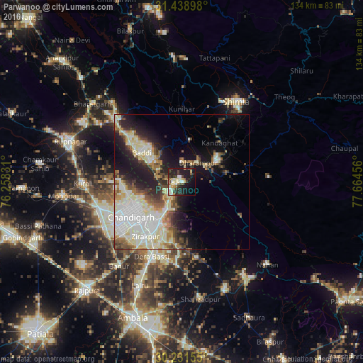
Analysis of Parwanoo night lights 2016
Square area 10x10 km:
 3.15%
3.15%90-99
8.22%80-89
6.47%70-79
3.15%60-69
2.62%50-59
4.37%40-49
5.59%30-39
11.71%20-29
14.86%10-19
26.22%0-9
13.64%Square area 50x50 km:
6.5%90-99
7.55%80-89
4.57%70-79
2.21%60-69
2.91%50-59
2.95%40-49
3.51%30-39
3.42%20-29
5.77%10-19
11.66%0-9
48.95%Clear (daylight) street map image can be seen on geolist.org.
Map coordinates:
31° 26' 20.3" North, 76° 15' 29.9" East
30° 50' 13.8" North, 76° 57' 41.1" East
30° 13' 53.6" North, 77° 39' 52.4" East
Some cities around Parwanoo sort by population:
• Chandigarh
20 km =12.4 mi,  235°
235°
• Panchkula
19.1 km =11.9 mi,  213°
213°
• Solan
16.2 km =10.1 mi,  60°
60°
• Kālka
2 km =1.2 mi,  278°
278°
• Pinjaur
5.9 km =3.7 mi,  223°
223°
• Baddi
21.1 km =13.1 mi,  309°
309°
• Sabāthu
15.6 km =9.7 mi,  10°
10°
• Kasauli
6.8 km =4.2 mi,  3°
3°
7279750 (p: 8,609)
Sources (retrieved 2019-11-25):
» Earth at Night: Flat Maps 2012, 2016