Richha night lights from space
Night Light of Richha (Uttar Pradesh) from space (India) Src. Average luminocity for 10x10km area is 5.7898% and for 50x50km: 11.0629%.
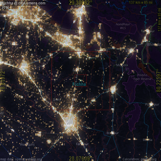
Analysis of Richha night lights 2016
Square area 10x10 km:
 0%
0%90-99
0%80-89
0%70-79
1.33%60-69
0.19%50-59
0%40-49
1.14%30-39
4.92%20-29
1.89%10-19
1.52%0-9
89.02%Square area 50x50 km:
0.59%90-99
0.97%80-89
0.67%70-79
0.69%60-69
1.06%50-59
2.1%40-49
2.96%30-39
3.64%20-29
4.4%10-19
9.77%0-9
73.16%Clear (daylight) street map image can be seen on geolist.org.
Map coordinates:
29° 18' 34.6" North, 78° 49' 11" East
28° 41' 40.8" North, 79° 31' 22.2" East
28° 4' 33.9" North, 80° 13' 33.5" East
Some cities around Richha sort by population:
• Baheri
9.2 km =5.7 mi,  344°
344°
• Kichha
24.1 km =15 mi,  359°
359°
• Nawābganj
20.3 km =12.6 mi,  147°
147°
• Shīshgarh
20.7 km =12.9 mi,  280°
280°
• Deoraniān
8.5 km =5.3 mi,  212°
212°
• Shāhi
25.7 km =16 mi,  231°
231°
• Shergarh
15.8 km =9.8 mi,  252°
252°
• Jahānābād
20.4 km =12.7 mi,  110°
110°
1258164 (p: 19,459)
Sources (retrieved 2019-11-25):
» Earth at Night: Flat Maps 2012, 2016