Deoraniān night lights from space
Night Light of Deoraniān (Uttar Pradesh) from space (India) Src. Average luminocity for 10x10km area is 14.875% and for 50x50km: 12.2266%.
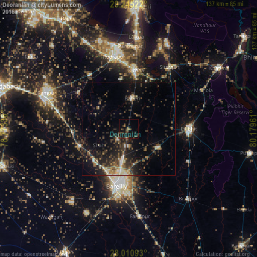
Analysis of Deoraniān night lights 2016
Square area 10x10 km:
 0%
0%90-99
0.38%80-89
0%70-79
2.46%60-69
0.57%50-59
4.36%40-49
5.49%30-39
4.92%20-29
4.92%10-19
16.67%0-9
60.23%Square area 50x50 km:
0.64%90-99
1.39%80-89
1.21%70-79
0.95%60-69
1.25%50-59
2.25%40-49
2.9%30-39
3.73%20-29
4.88%10-19
8.83%0-9
71.98%Clear (daylight) street map image can be seen on geolist.org.
Map coordinates:
29° 14' 42.8" North, 78° 46' 24.1" East
28° 37' 47.6" North, 79° 28' 35.3" East
28° 0' 39.3" North, 80° 10' 46.6" East
Some cities around Deoraniān sort by population:
• Baheri
16.2 km =10.1 mi,  7°
7°
• Nawābganj
18.3 km =11.4 mi,  122°
122°
• Fatehganj West
24.6 km =15.3 mi,  222°
222°
• Shīshgarh
19.3 km =12 mi,  305°
305°
• Richha
8.5 km =5.3 mi,  32°
32°
• Shāhi
17.9 km =11.1 mi,  240°
240°
• Shergarh
10.8 km =6.7 mi,  282°
282°
• Jahānābād
23.6 km =14.7 mi,  89°
89°
1273206 (p: 19,788)
Sources (retrieved 2019-11-25):
» Earth at Night: Flat Maps 2012, 2016