Rāy night lights from space
Night Light of Rāy (Jharkhand) from space (India) Src. Average luminocity for 10x10km area is 61.3631% and for 50x50km: 11.9133%.
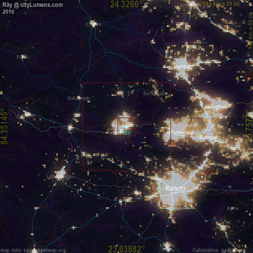
Analysis of Rāy night lights 2016
Square area 10x10 km:
 17.66%
90-99
16.47%80-89
6.75%70-79
1.59%60-69
10.32%50-59
8.53%40-49
5.75%30-39
7.14%20-29
10.91%10-19
12.3%0-9
2.58%Square area 50x50 km:
1.77%90-99
1.84%80-89
0.94%70-79
0.63%60-69
1.39%50-59
1.65%40-49
2.34%30-39
2.32%20-29
4.13%10-19
7.9%0-9
75.1%Clear (daylight) street map image can be seen on geolist.org.
Map coordinates:
24° 19' 35.8" North, 84° 21' 5.2" East
23° 41' 3.5" North, 85° 3' 16.5" East
23° 2' 19.8" North, 85° 45' 27.7" East
Some cities around Rāy sort by population:
• Ranchi
46 km =28.6 mi,  145°
145°
• Hazāribāgh
46.4 km =28.8 mi,  42°
42°
• Rāmgarh
47.9 km =29.8 mi,  97°
97°
• Lohārdagā
47.3 km =29.4 mi,  233°
233°
• Lātehār
56.9 km =35.4 mi,  276°
276°
• Kuju
46.6 km =29 mi,  84°
84°
• Barkā Kānā
42.6 km =26.5 mi, 99°
• Kānke
38.8 km =24.1 mi,  135°
135°
1258293 (p: 5,949)
Sources (retrieved 2019-11-25):
» Earth at Night: Flat Maps 2012, 2016