Pupri night lights from space
Night Light of Pupri (Bihar) from space (India) Src. Average luminocity for 10x10km area is 13.1098% and for 50x50km: 12.662%.
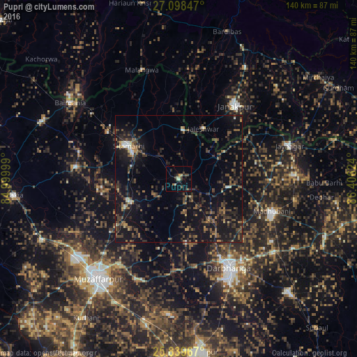
Analysis of Pupri night lights 2016
Square area 10x10 km:
 0%
0%90-99
1.89%80-89
1.33%70-79
1.7%60-69
1.89%50-59
0.76%40-49
2.65%30-39
3.41%20-29
4.92%10-19
4.73%0-9
76.7%Square area 50x50 km:
0.42%90-99
0.68%80-89
0.63%70-79
0.82%60-69
1.67%50-59
2.29%40-49
3.94%30-39
3.4%20-29
5.38%10-19
14.93%0-9
65.83%Clear (daylight) street map image can be seen on geolist.org.
Map coordinates:
27° 5' 54.5" North, 84° 59' 60" East
26° 28' 14.8" North, 85° 42' 11.2" East
25° 50' 22.8" North, 86° 24' 22.5" East
Some cities around Pupri sort by population:
• Darbhanga
40.4 km =25.1 mi,  151°
151°
• Janakpur, NP
36.3 km =22.6 mi,  37°
37°
• Madhubani
38.9 km =24.2 mi,  109°
109°
• Sītāmarhi
25.2 km =15.7 mi,  302°
302°
• Sheohar
41.1 km =25.5 mi,  276°
276°
• Jaleshwar, NP
22.1 km =13.7 mi,  25°
25°
• Belsand
30.2 km =18.8 mi,  264°
264°
• Dumra
21.1 km =13.1 mi, 300°
1259210 (p: 15,070)
Sources (retrieved 2019-11-25):
» Earth at Night: Flat Maps 2012, 2016