Belsand night lights from space
Night Light of Belsand (Bihar) from space (India) Src. Average luminocity for 10x10km area is 25.3068% and for 50x50km: 14.1758%.
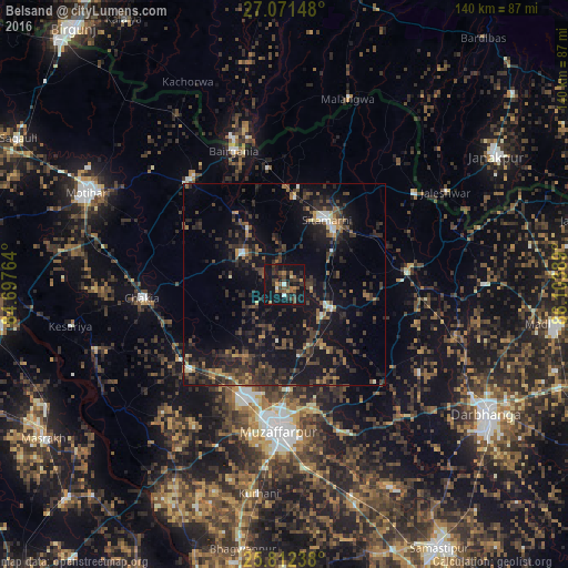
Analysis of Belsand night lights 2016
Square area 10x10 km:
 1.14%
1.14%90-99
1.14%80-89
1.33%70-79
3.22%60-69
3.79%50-59
3.6%40-49
8.9%30-39
8.14%20-29
7.01%10-19
41.67%0-9
20.08%Square area 50x50 km:
0.56%90-99
0.76%80-89
0.63%70-79
1.15%60-69
1.51%50-59
2.61%40-49
4.22%30-39
4.38%20-29
7.42%10-19
16.77%0-9
59.98%Clear (daylight) street map image can be seen on geolist.org.
Map coordinates:
27° 4' 17.3" North, 84° 41' 51.5" East
26° 26' 37.1" North, 85° 24' 2.7" East
25° 48' 44.6" North, 86° 6' 14" East
Some cities around Belsand sort by population:
• Muzaffarpur
35.7 km =22.2 mi,  181°
181°
• Sītāmarhi
18.9 km =11.7 mi,  28°
28°
• Bairāgnia
35.4 km =22 mi,  338°
338°
• Dhāka
34.7 km =21.6 mi,  317°
317°
• Sheohar
13.2 km =8.2 mi,  306°
306°
• Chākia
35.4 km =22 mi,  265°
265°
• Dumra
18.2 km =11.3 mi,  40°
40°
• Pupri
30.2 km =18.8 mi,  84°
84°
1276495 (p: 19,396)
Sources (retrieved 2019-11-25):
» Earth at Night: Flat Maps 2012, 2016