Dumra night lights from space
Night Light of Dumra (Bihar) from space (India) Src. Average luminocity for 10x10km area is 38.911% and for 50x50km: 10.8756%.
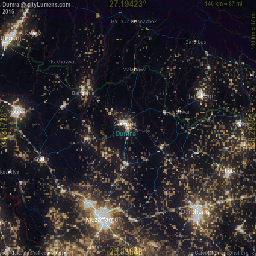
Analysis of Dumra night lights 2016
Square area 10x10 km:
 5.87%
5.87%90-99
7.2%80-89
3.41%70-79
3.98%60-69
3.98%50-59
9.47%40-49
4.73%30-39
6.82%20-29
12.88%10-19
30.68%0-9
10.98%Square area 50x50 km:
0.67%90-99
0.75%80-89
0.65%70-79
0.76%60-69
1.3%50-59
1.9%40-49
2.7%30-39
2.86%20-29
4.68%10-19
11.18%0-9
72.55%Clear (daylight) street map image can be seen on geolist.org.
Map coordinates:
27° 11' 39.2" North, 84° 49' 2.2" East
26° 34' 1.5" North, 85° 31' 13.4" East
25° 56' 11.3" North, 86° 13' 24.7" East
Some cities around Dumra sort by population:
• Sītāmarhi
4.2 km =2.6 mi,  314°
314°
• Bairāgnia
31.2 km =19.4 mi, 308°
• Gaur, NP
32.6 km =20.3 mi, 312°
• Sheohar
23.3 km =14.5 mi,  255°
255°
• Jaleshwar, NP
29.3 km =18.2 mi,  71°
71°
• Malaṅgawā, NP
32.4 km =20.1 mi,  6°
6°
• Belsand
18.2 km =11.3 mi,  220°
220°
• Pupri
21.1 km =13.1 mi,  120°
120°
1272229 (p: 15,778)
Sources (retrieved 2019-11-25):
» Earth at Night: Flat Maps 2012, 2016