Pratāpgarh night lights from space
Night Light of Pratāpgarh (Uttar Pradesh) from space (India) Src. Average luminocity for 10x10km area is 56.7008% and for 50x50km: 23.3052%.
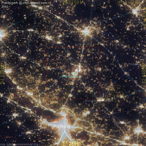
Analysis of Pratāpgarh night lights 2016
Square area 10x10 km:
 7.58%
7.58%90-99
13.64%80-89
3.79%70-79
7.39%60-69
8.14%50-59
14.02%40-49
12.12%30-39
11.36%20-29
17.05%10-19
4.92%0-9
0%Square area 50x50 km:
0.69%90-99
1.11%80-89
0.66%70-79
1.84%60-69
3.12%50-59
5.09%40-49
7.99%30-39
8.61%20-29
11.61%10-19
26.06%0-9
33.21%Clear (daylight) street map image can be seen on geolist.org.
Map coordinates:
26° 31' 33.3" North, 81° 14' 21.4" East
25° 53' 42.3" North, 81° 56' 32.6" East
25° 15' 39.2" North, 82° 38' 43.9" East
Some cities around Pratāpgarh sort by population:
• Sultānpur
42.4 km =26.3 mi,  17°
17°
• Bela
6.1 km =3.8 mi,  62°
62°
• Lālganj
24.1 km =15 mi,  279°
279°
• Phulpur
41.2 km =25.6 mi,  159°
159°
• Mau Aimma
22.3 km =13.9 mi,  184°
184°
• Amethī
32.2 km =20 mi,  334°
334°
• Patti
26 km =16.2 mi,  83°
83°
• Antu
18.4 km =11.4 mi,  347°
347°
1259337 (p: 13,672)
Sources (retrieved 2019-11-25):
» Earth at Night: Flat Maps 2012, 2016