Patti night lights from space
Night Light of Patti (Uttar Pradesh) from space (India) Src. Average luminocity for 10x10km area is 21.839% and for 50x50km: 17.3672%.
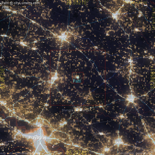
Analysis of Patti night lights 2016
Square area 10x10 km:
 0.57%
0.57%90-99
2.46%80-89
1.7%70-79
0.57%60-69
1.14%50-59
3.03%40-49
5.68%30-39
10.04%20-29
12.88%10-19
22.35%0-9
39.58%Square area 50x50 km:
0.56%90-99
0.93%80-89
0.51%70-79
0.97%60-69
2.11%50-59
3.22%40-49
5.93%30-39
6.72%20-29
9.13%10-19
17.4%0-9
52.53%Clear (daylight) street map image can be seen on geolist.org.
Map coordinates:
26° 33' 7.8" North, 81° 29' 50.5" East
25° 55' 17.4" North, 82° 12' 1.7" East
25° 17' 14.7" North, 82° 54' 13" East
Some cities around Patti sort by population:
• Sultānpur
39.5 km =24.5 mi,  341°
341°
• Bela
20.4 km =12.7 mi,  269°
269°
• Machhlīshahr
33.6 km =20.9 mi,  141°
141°
• Phulpur
42.9 km =26.7 mi,  195°
195°
• Mau Aimma
37.5 km =23.3 mi,  227°
227°
• Pratāpgarh
26 km =16.2 mi,  263°
263°
• Antu
33.3 km =20.7 mi,  296°
296°
• Kādīpur
32.2 km =20 mi,  31°
31°
1260046 (p: 9,685)
Sources (retrieved 2019-11-25):
» Earth at Night: Flat Maps 2012, 2016