Pippara night lights from space
Night Light of Pippara (Andhra Pradesh) from space (India) Src. Average luminocity for 10x10km area is 3.6472% and for 50x50km: 12.7728%.
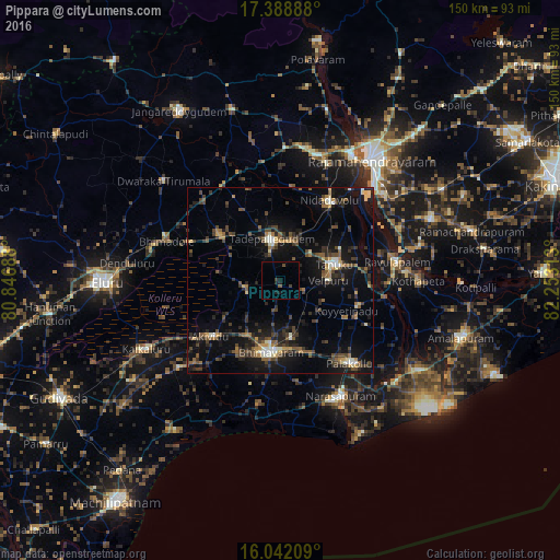
Analysis of Pippara night lights 2016
Square area 10x10 km:
 0%
0%90-99
0%80-89
0%70-79
0%60-69
0%50-59
0.87%40-49
1.08%30-39
1.52%20-29
0.87%10-19
3.46%0-9
92.21%Square area 50x50 km:
0.27%90-99
1.56%80-89
0.99%70-79
1.08%60-69
1.34%50-59
2.26%40-49
3.32%30-39
3.25%20-29
4.29%10-19
11.52%0-9
70.11%Clear (daylight) street map image can be seen on geolist.org.
Map coordinates:
17° 23' 20" North, 80° 50' 48.8" East
16° 43' 0" North, 81° 33' 0" East
16° 2' 31.5" North, 82° 15' 11.3" East
Some cities around Pippara sort by population:
• Bhīmavaram
19.8 km =12.3 mi,  188°
188°
• Tādepallegūdem
11.2 km =7 mi,  347°
347°
• Tanuku
14.6 km =9.1 mi,  73°
73°
• Attili
5.6 km =3.5 mi,  109°
109°
• Pālakollu
29.4 km =18.3 mi,  139°
139°
• Nidadavole
24.7 km =15.3 mi,  31°
31°
• Akivīdu
23.4 km =14.5 mi,  230°
230°
• Penugonda
22 km =13.7 mi, 108°
1259562 (p: 8,581)
Sources (retrieved 2019-11-25):
» Earth at Night: Flat Maps 2012, 2016