Pipili night lights from space
Night Light of Pipili (Odisha) from space (India) Src. Average luminocity for 10x10km area is 37.0139% and for 50x50km: 29.3115%.
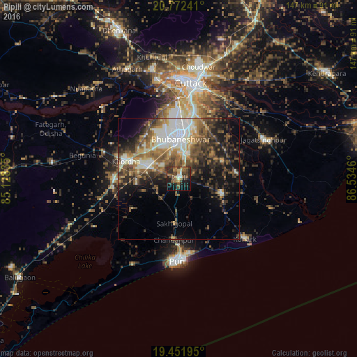
Analysis of Pipili night lights 2016
Square area 10x10 km:
 1.79%
1.79%90-99
3.57%80-89
1.79%70-79
4.17%60-69
9.92%50-59
7.54%40-49
11.11%30-39
11.31%20-29
16.47%10-19
22.22%0-9
10.12%Square area 50x50 km:
3.59%90-99
6.73%80-89
2.27%70-79
3.25%60-69
4.41%50-59
5.89%40-49
5.81%30-39
5.95%20-29
7.15%10-19
11.88%0-9
43.08%Clear (daylight) street map image can be seen on geolist.org.
Map coordinates:
20° 46' 20.7" North, 85° 7' 42.1" East
20° 6' 48.9" North, 85° 49' 53.3" East
19° 27' 7" North, 86° 32' 4.6" East
Some cities around Pipili sort by population:
• Bhubaneshwar
17.7 km =11 mi,  0°
0°
• Cuttack
39.4 km =24.5 mi,  7°
7°
• Puri
35.1 km =21.8 mi,  181°
181°
• Jatani
13.9 km =8.6 mi,  291°
291°
• Khurda
23.7 km =14.7 mi, 288°
• Jagatsinghapur
38.8 km =24.1 mi,  65°
65°
• Nimāparha
19.1 km =11.9 mi,  109°
109°
• Konārka
38.1 km =23.7 mi,  129°
129°
1259592 (p: 15,301)
Sources (retrieved 2019-11-25):
» Earth at Night: Flat Maps 2012, 2016