Nimāparha night lights from space
Night Light of Nimāparha (Odisha) from space (India) Src. Average luminocity for 10x10km area is 22.629% and for 50x50km: 17.8948%.
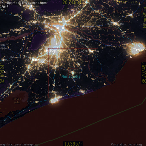
Analysis of Nimāparha night lights 2016
Square area 10x10 km:
 0.79%
0.79%90-99
2.78%80-89
1.19%70-79
2.18%60-69
1.79%50-59
3.17%40-49
1.59%30-39
12.5%20-29
10.71%10-19
29.37%0-9
33.93%Square area 50x50 km:
1.68%90-99
3.05%80-89
0.93%70-79
1.91%60-69
2.68%50-59
3.25%40-49
3.97%30-39
5.04%20-29
6.19%10-19
10.64%0-9
60.65%Clear (daylight) street map image can be seen on geolist.org.
Map coordinates:
20° 42' 59.9" North, 85° 18' 4.5" East
20° 3' 27.2" North, 86° 0' 15.7" East
19° 23' 44.5" North, 86° 42' 27" East
Some cities around Nimāparha sort by population:
• Bhubaneshwar
29.8 km =18.5 mi,  323°
323°
• Cuttack
47.1 km =29.3 mi,  343°
343°
• Puri
34.4 km =21.4 mi,  213°
213°
• Jatani
33 km =20.5 mi,  290°
290°
• Khurda
42.8 km =26.6 mi, 288°
• Jagatsinghapur
28.1 km =17.5 mi,  38°
38°
• Konārka
21.2 km =13.2 mi,  147°
147°
• Pipili
19.1 km =11.9 mi, 289°
1261375 (p: 18,222)
Sources (retrieved 2019-11-25):
» Earth at Night: Flat Maps 2012, 2016